套用介紹
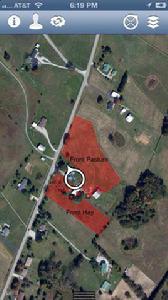
iGeoTrak是一款可以讓用戶定製的現場數據採集到iPad功能的移動協作產品。 數字筆記本利用地理信息系統,圖像,它可以讓你在iPad上,任何地點、任何時候都更好的規劃,文檔和管理您的業務。任何資產,欄位或工作秩序的歷史或當前狀態,只需輕按在地圖上,並選擇您想要顯示的信息。其主要功能如下:
計畫:創建一個工作計畫時間表,涵蓋了所有的任務,並投入迅速。分配勞動分配使用直觀的計時接口。在日曆上查看序列數據。
任務:把你的計畫訂單,設備和員工投入到工作中。分配的任務,文檔的形式,和事件信息(日期,時間,設備等)。跟隨只是一個同步的進展。 測量標誌,消防栓,電線桿,養護,材料和設備的使用,更在多個區域水平。
文獻:資產跟蹤,問題,排定的工作,以及更多。使用素描,注釋問題地區或亮點信息。
顯示:航拍照片 - 意象,分析圖像,地理信息系統的邊界和功能,您的測量位置,以及更多。請參閱您的位置疊加柵格上。
實錄:任何與工作相關的變數(表單和測量是完全可定製)通過基於地圖的可視化的照片,條形碼和文本/音頻票據。設備,人員,和其他資產的使用,每個區域。 ?註解/素描區域調用。
報告:報告在iPad上的地圖繪製。更複雜的檔案報告的ipad或網頁。訂閱,批次,或在同一時間在一些開放的格式之一,HTML,PDF,RTF,XLS,CSV。 iGeoTrak設有背景定位跟蹤用戶的位置(可以產生不利影響電池壽命)和天氣。
iGeoTrak brings user customizable field data collection to iPad enabled collaborative mobile teams. Make digital all your notebooks, 3-ring binders, GIS, imagery, and have it available on your iPad at all times for better planning, documentation, and management of your operations. Turn your existing paper and processes into your new digital multi user collaboration tool. To know the history or current status of any asset, field, or work order just tap on the map and select the information you want displayed. Everything works even when WiFi/3G/4G is not available. Plan: Create a work plan schedule that covers all your tasks and inputs quickly. Assign labor allocation using an intuitive time keeping interface. View the data in sequence on a calendar. Task: Turn your plans into work orders for equipment and employees. Assign the task, the documentation form, and the event information (time, date, equipment, etc.). Follow along with progress with just a sync. Measure: Signs, hydrants, poles, conservation, material and equipment use, and more at multiple zone levels. Document: Asset tracking, problems, scheduled work, and more. Use sketching to annotate problems areas or highlight information. Display: Aerial images - Imagery, analysis images, GIS boundaries and features, location of your measurements, and much more. See your location superimposed on your rasters. Record: Any work related variable (forms and measurements are completely customizable) through a map-based visualization with photos, barcodes, and text/audio notes. Equipment, personnel, and other asset usage per zone. Annotations/sketching of the zone to call up later. Report: Reports on the ipad maps with plotting. More complex paper reports from the ipad or the web. Subscribe, batch, or one at a time in a number of open formats; HTML, PDF, RTF, XLS, CSV. iGeoTrak features background location tracking (can adversely affect battery life) and weather at the user's locations.
支持版本
iOS5.0及以上

